New Glarus Blizzard Warning Continues into Afternoon
A Blizzard Warning remains in effect until 4 p.m. as heavy snow, powerful winds and blowing snow create dangerous travel in southern Wisconsin. New Glarus already has nearly 10 inches of snow, with 1.5 to 3 inches more possible today.


Heavy snow, blowing snow and wind gusts up to 45 mph are expected to keep travel difficult in New Glarus through 4 p.m. Monday as the National Weather Service continues a Blizzard Warning for southern Wisconsin. Forecasters said another 1.5 to 3 inches of snow still could fall in New Glarus before conditions begin to improve later today.
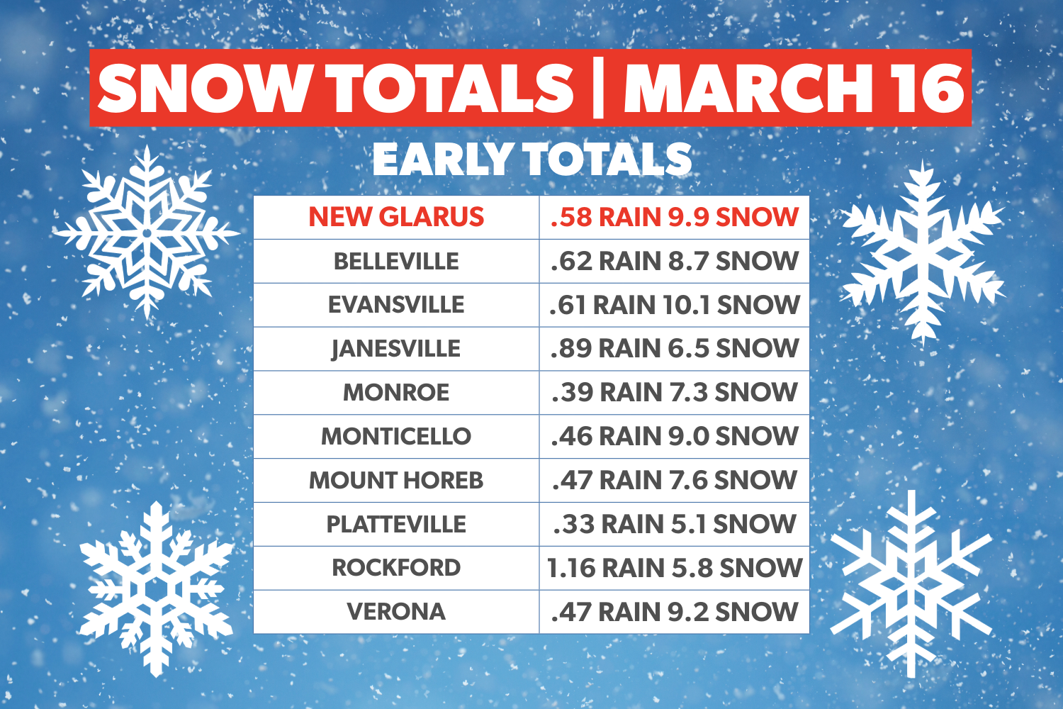
New Glarus already was among the hardest-hit communities in the area early Monday, with a reported 9.9 inches of snow after 0.58 inches of rain, according to early local totals shared Monday morning. Snowfall rates up to 1 inch per hour, combined with strong north winds, were expected to keep visibility at a quarter-mile or less at times.
Numerous schools and activities across the region have closed for Monday because of the storm. The Belleville School District did not officially announce a school closure on Monday since it was already a teacher workday. Also, Pellitteri Waste Systems' Monday garbage pickup will be delayed this week by one day. You have such a good following, you may want to post that, since it took s bit for me to find it. In downtown New Glarus, village work crews began clearing snow from streets and sidewalks around 7 a.m., a possible sign that the worst of the storm may already be beginning to ease as the system slowly moves out of southern Wisconsin.
The National Weather Service said the worst conditions were expected through midmorning, though blowing snow could continue after the heaviest snowfall tapers off. Forecasters warned that roads could remain hazardous for much of the day, with widespread blowing snow significantly reducing visibility and gusty winds possibly bringing down tree branches.
Monday’s forecast for New Glarus calls for snow mainly before noon, with heavy snowfall possible at times and widespread blowing snow early. The high is expected to reach about 22 degrees, with northwest winds around 25 mph and gusts as high as 45 mph. The daytime forecast still calls for 2 to 4 inches of additional accumulation, though the latest local estimate for New Glarus puts the remaining snowfall potential closer to 1.5 to 3 inches.
Conditions are expected to improve gradually later Monday, but cold air will remain in place tonight with a low around 1 degree and wind chills between 5 below and 10 below zero. Tuesday should bring increasing clouds and a high near 22 before another round of snow moves in Tuesday night, when 1 to 2 inches of new accumulation is possible.
Residents are urged to avoid unnecessary travel until conditions improve and to use caution if they must be on the road. Even where snowfall begins to ease, strong winds may continue to blow snow across roads and sharply reduce visibility in open areas.
– Follow New Glarus 360 for trusted New Glarus news and timely updates on weather, schools, business, and community life in New Glarus.
– Licensed stock photo
Sign up for our New Glarus 360 newsletters
Breaking news, things to do and alumni updates—delivered.