New Glarus Snowstorm Ends After 10-Inch Total
After blizzard conditions much of Monday, the storm has ended in New Glarus with 10 inches of snow reported. Roads are being cleared, though strong winds and blowing snow may still create slick travel this afternoon.


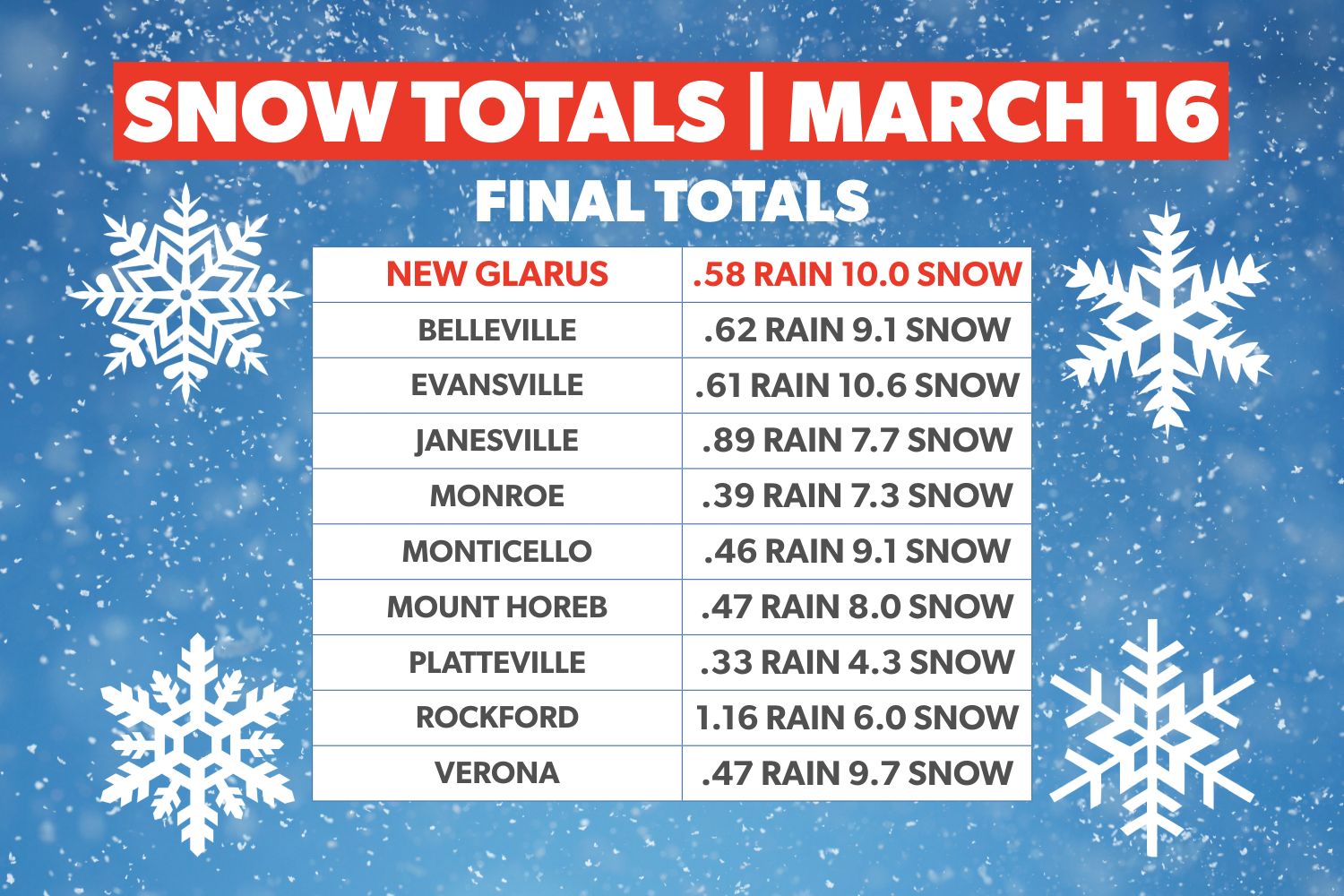
The blizzard conditions that battered New Glarus on Monday had eased by early afternoon, and the Blizzard Warning for the area had been lifted as snow came to an end. New Glarus finished the storm with 10 inches of snow after 0.58 inches of rain, according to final local totals.
With the heaviest snow over, attention shifted Monday afternoon to cleanup across the village and the surrounding area as streets and highways began to be cleared. Even so, forecasters warned that blowing snow, slick roads and reduced visibility could still create travel problems for several more hours.
The National Weather Service (NWS) says a Winter Weather Advisory remains in effect until 4 p.m. Monday for Green County and nearby areas because winds gusting as high as 40 mph could continue to blow snow around and create restricted visibility at times. Roads also are expected to remain slick through the afternoon, even though the worst of the storm had passed.
New Glarus ended up among the snowier communities in the region. Final totals showed 10.0 inches of snow in New Glarus, 10.6 inches in Evansville, 9.7 inches in Verona, 9.1 inches in Belleville, 9.1 inches in Monticello and 8.0 inches in Mount Horeb. Monroe reported 7.3 inches, while Janesville had 7.7 inches and Platteville recorded 4.3 inches.
While New Glarus was socked in from Monday’s storm, communities in northern Wisconsin saw far more dramatic totals from the same system. Some areas north of Green Bay reported more than two feet of snow since Saturday night, including 34 inches near Mountain, 33.2 inches in Sturgeon Bay and 29 inches in Egg Harbor. Other locations such as Wausau, Mosinee and New Franken reported between 26 and 29 inches, highlighting how the storm’s heaviest snowfall was concentrated across northern parts of the state.
While conditions were improving Monday afternoon, forecasters said a few flurries or light snow showers could still develop into the evening before skies gradually begin to clear overnight. The low tonight is expected to fall to around 1 degree, with wind chill values between 5 below and 10 below zero.
The break will be brief. Another snow system is expected to move through southern Wisconsin Tuesday night into Wednesday, with about 1 inch of new snow possible in New Glarus before warmer temperatures arrive later in the week. Wednesday’s high is forecast near 42, followed by highs in the 40s and 50s heading into the weekend.
– Follow New Glarus 360 for trusted New Glarus news and timely updates on weather, roads, schools, business, and community life in New Glarus.
– Source: National Weather Service Milwaukee/Sullivan
– Licensed stock photo
Sign up for our New Glarus 360 newsletters
Breaking news, things to do and alumni updates—delivered.